GIS Support Services joins earthquake-relief efforts with mapathon training
In response to the catastrophic earthquake that struck Turkey and Syria in February, Yale Library’s GIS Support Services teamed with the Yale Center for Earth Observation (YCEO) to answer an urgent call to action.
Miriam Olivares, GIS librarian, hosted an afternoon geospatial mapping workshop with Tarek Kandakji, remote sensing specialist in the School of the Environment and the manager of YCEO. GIS Support Services assists users in cross-disciplinary applications of geographic information systems. YCEO specializes in the study of the earth from space via remote-sensing satellites.
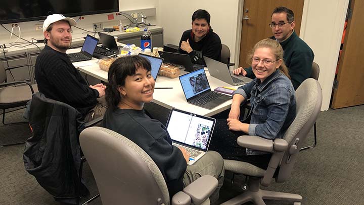
The Yale students and staff participating in the two-hour workshop were trained in how to contribute to a “mapathon”—a crowdsourced, wiki-style effort to improve geospatial databases of partially or obsoletely mapped regions.
In a mapathon, volunteers work online to map the locations of roads, hospitals, and essential services in regions devastated by natural or humanitarian disasters. The updated maps help organizations and first responders on the ground assess damage, navigate through affected areas, locate resources, and deliver aid. “In the past,” Olivares said, “Yale students have organized mapathons right after natural disasters, and we have assisted their efforts by providing a venue and our mapping expertise.”
To assist with the Turkey-Syria project, workshop participants worked with OpenStreetMap, geospatial software developed by HOT (Humanitarian OpenStreetMap Team). HOT coordinated with Yer Çizenler, an open mapping community in Turkey, to launch this project.
After some initial training, the ten workshop volunteers—beginners and more experienced mappers—helped flag the locations of food markets in sections of Turkey and Syria. They also provided addresses and additional information to further assist those conducting relief efforts.
“The earthquake mostly affected my home country of Syria, which is already suffering from significant damage to infrastructure and the economic crisis caused by ongoing war,” Kandakji said. “This collective effort helps create a foundational map that can be utilized by services worldwide.”
Learn more about Yale Library’s GIS Support Services and about other GIS workshops.
Learn more about the disaster-response mapping project in Turkey and Syria. Work on this project is ongoing, as are other HOT projects for regions in crisis.
—Deborah Cannarella
Images: Volunteers during the mapathon training session at the Yale Center for Earth Observation. Photo by Miriam Olivares.