PhD candidate named Yale’s EIP Student of the Year for innovative geospatial mapping
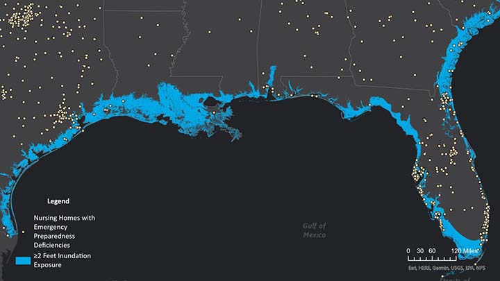

Natalia Festa, first-year PhD candidate in Investigative Medicine, researches the preparedness of nursing homes in the event of emergencies—like the 2022 hurricane-induced floodings of facilities in Florida, Mississippi, and Texas.
Essential to Festa’s work is the ability to identify those locations at risk, which she does by analyzing geospatial data. As essential tools, she has relied on Yale’s Geographic Information Systems (GIS) resources and the support that Yale faculty and the library’s GIS Support Team offers.
The Esri Prize
This year, in recognition of her innovative research methods, Festa has been named Yale’s Esri Innovation Program (EIP) Student of the Year. Esri is the software company that developed Yale’s ArcGIS suite of products. Yale is one of a select group of universities that are members of the EIP, whose goal is to advance geospatial science in research and education by offering technical expertise, resources, and support.
“The purpose of the award,” said GIS librarian Miriam Olivares, is “to recognize outstanding achievements in developing novel tools or techniques for geospatial analysis. EIP student nominees demonstrate their knowledge and understanding of GIS and its value by building outstanding apps and projects on Esri’s ArcGIS platform, combined with other tools and software.”
Festa is only the fourth student to be named Yale’s EIP Student of the Year. Esri will award her a $500 cash prize, an Esri Press book, and a certificate of recognition.
Festa’s StoryMap, a digital publication of her research created with the ArcGIS StoryMap platform, will also appear on the EIP website. The title is “Coastal Nursing Home Emergency Preparedness Regulation: Evaluating Regulatory Responsiveness to Environmental Risk.”
“To date, little is understood regarding emergency preparedness for vulnerable population subgroups, such as nursing home residents,” Festa said. “Improved understanding of these relationships should enhance the age-friendliness and precision of adaptation efforts by healthcare facilities and state and local governments.”
Resources and support
Festa holds an MD and MBA from Stanford University. In 2021, after completing her training in Geriatrics at Yale, Festa wanted to learn more about GIS, which she understood would be invaluable to her work. She approached Jill Kelly, GIS instructor in the department of environmental health sciences in the School of Public Health, about auditing two introductory courses. That experience motivated Festa to return to Yale in the Graduate School of Arts and Science to pursue her PhD in Investigative Medicine. She also further developed her GIS skills by enrolling in formal courses and in the Yale GIS Accelerator, a one-week-long intensive geospatial training session the library offers.
“Learning geospatial analysis has been a central and formative component of my doctoral training as I pursue this line of research,” Festa said.
Kelly and Charles Dana Tomlin, the GIS instructor in the School of the Environment, nominated Festa for the Esri prize. “In August of 2021,” Kelly wrote in support of the nomination, “Natalia was a complete novice in GIS. Eighteen months of diligent and independent hard work have brought her sufficient technical knowledge and theoretical understanding to produce papers for publication applying GIS methods in innovative ways. I have never seen a student make such rapid progress.”
All Yale members have access to the web-based and desktop GIS software and also to free virtual training. “Yale Library has been great in increasing the GIS footprint across campus,” Olivares said. University-wide access to ArcGIS promotes networking and collaboration among researchers throughout the Yale community who are engaged in geospatial work.
Festa is also a candidate for the EIP Student of the Year global competition, which will be decided in June.
View Natalia Festa’s StoryMap.
Read more about Yale Library’s Geographic Information Systems resources and other online mapping resources.
Read about the projects of the three previous recipients of Yale’s EIP Student of the Year award.
—Deborah Cannarella
Images: Detail from Festa’s StoryMap, showing (as white dots) nursing homes along Atlantic and Gulf coastlines at risk of exposure to 2 feet or more of hurricane-related inundation, when roads become impassable for ground evacuation; portrait of Natalia Festa